



It has been a punishing year for American weather. Massive wildfires tore through California, a record-shattering heat dome baked the summer, and a historic deep freeze gripped more than 1,800 miles of the country over the winter. Twelve separate billion-dollar climate disasters struck in just the first half of 2026, alongside a run of severe storms, tornado outbreaks, high winds and flash floods. Meteorologists warned early in the year that El Niño would return to reshape weather patterns worldwide in 2026, and now, as the event strengthens into the fall, one question keeps coming up: how much of this is El Niño?
What exactly is El Niño?
Picture the tropical Pacific Ocean as a giant heat reservoir. Normally, trade winds blow from east to west, pushing warm surface water toward Indonesia and Australia and allowing cold, nutrient-rich water to rise along the western coast of South America. During El Niño, those trade winds weaken. The vast pool of warm water shifts eastward into the central and eastern Pacific, releasing extra heat and moisture into the atmosphere and disrupting the jet streams that steer weather systems around the globe.
The name itself means “the little boy” in Spanish — Peruvian fishermen coined it after noticing unusually warm coastal waters around Christmastime.
READ: Washington wildfires devastate Spokane area as thousands flee (August 3, 2026)
What it means for the United States
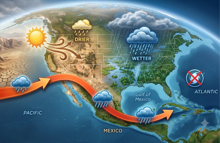
El Niño’s effects on the U.S. are most pronounced in winter, especially January through March. The mechanism is straightforward: El Niño tends to push the Pacific jet stream southward, steering more storms toward the southern tier of the country, as the table below shows.
| Region | Typical El Niño Winter Effect |
|---|---|
| Southern California → Gulf Coast → Southeast | Wetter |
| Southern U.S. | Often cooler |
| Northern U.S. | Often warmer |
| Northern Rockies | Often drier |
| California | Greater chance of substantial precipitation |
| Southern states | More frequent winter storms |
That shift is a mixed blessing. More rain can ease drought and refill reservoirs, but too much can trigger flooding, landslides and other damage — the historic El Niños of 1982–83 and 1997–98 dumped extraordinary rainfall on California. NOAA is careful to note that not every El Niño produces such extremes.
The pattern reaches offshore, too: Atlantic hurricanes tend to be suppressed during El Niño, as stronger upper-level winds disrupt storm development, while hurricane activity often increases in the central and eastern Pacific.
Why 2026 looks different
This isn’t just theoretical. NOAA’s July 2026 assessment found El Niño has strengthened, with sea-surface temperatures in the Niño-3.4 region running about 1.2°C above normal, and the agency puts the odds at 97% that the event will persist through early spring 2027. That same outlook projected an 81% chance of a very strong event between October and December 2026 — and a striking 69% chance that it reaches historic strength, surpassing every El Niño recorded since 1950.
NOAA is careful to add a caveat: El Niño shifts the odds, but it doesn’t dictate the weather everywhere on every day, and other atmospheric patterns can amplify or dampen its influence.
“With an event of this magnitude, the chances of experiencing impacts consistent with El Niño are larger, but they are not guaranteed,” the agency’s Climate Prediction Center notes.
“Every El Niño is not the same; each one is unique with its own imprint on our weather,” said Ken Graham, director of NOAA’s National Weather Service.
NOAA frames the bigger picture this way: El Niño ranks among the most influential natural climate drivers precisely because heat changes in the tropical Pacific ripple outward, reshaping temperature, precipitation, agriculture, wildfire risk and fisheries across the globe. In short, El Niño is the periodic warming of the tropical Pacific that shifts the jet stream — and for the U.S., its clearest signature is a warmer, drier north and a wetter, stormier south each winter.
READ: Zohran Mamdani draws backlash with 78-degree AC recommendation amid NYC heat wave (July 3, 2026)
The real story is still ahead
For now, the biggest impacts are still to come. NOAA expects the strongest effects to hit this autumn and especially winter 2026–27, rather than the current summer. Meteorologists interviewed by The Colorado Sun stressed that El Niño isn’t behind the extraordinary summer heat currently baking the western U.S. — its influence over the continental U.S. is typically weak in summer and grows far more significant later in the year.
What forecasters expect this winter
By winter, forecasters expect a greater chance of heavy precipitation and snow across California and the southern tier, elevated flood and landslide risk in parts of the West, and a warmer, drier pattern farther north, including the northern Rockies and the Ohio and Tennessee valleys. The same atmospheric shift that fuels those storms also tends to suppress Atlantic hurricanes — one reason NOAA is forecasting a below-average 2026 Atlantic hurricane season.
Brian Lada, a meteorologist at AccuWeather, has emphasized that the most significant effects are still ahead, rather than El Niño being to blame for every unusual weather event happening right now. His forecast points to a more active southern storm track — and a bumpier ride in the skies, as a more energetic jet stream makes for rougher flights across the U.S. this winter.
It’s a fitting reminder that an ocean phenomenon unfolding thousands of miles away can eventually touch something as ordinary as a plane ride.